


Foto: The lighthouse of Urk (bron: Ronald van der Veer)
Netherlands - Urk has existed for more than 1000 years and was an island until 1939. That year, the dike from Lemmer to Urk was completed. In 1942, the Noordoostpolder was drained, and Urk definitively ceased to be an island. Since then, Urk has been a unique municipality with its own distinct culture and history, standing apart from the new, planner-designed municipalities in the polder. Especially when seen from the water, Urk offers a magnificent view. During a boat trip, this is clearly visible: the hill rising from the former Zuiderzee, with the contours of the low-lying polder behind it. The written history of Urk goes back to 966. That year, the island was first mentioned in official documents. Soil research of the Zuiderzee and historical data indicate that the water near Urk must have been fresh at that time. Urk is mentioned in 966 in charters as "an island in the Almare" and belonged to the Salland district. These charters state that Emperor Otto the Great gave one half of Urk to the Pantaleon Monastery in Cologne and the other half to the St. Vitus Abbey in Hoog-Elten. The island was about 80 hectares in size and consisted of a high boulder clay mound, the hill, and a meadow. On the 12-hectare hill were houses, churches, the lighthouse, and other buildings. The low-lying meadow regularly flooded before the polder was drained; now this area is also built-up. There is no definitive explanation for the island’s name. Linguistically, Urk is related to “Ork,” which among other meanings stands for: unruly, stubborn, unyielding. These concepts figuratively suit a height rising out of the water, like a rock. Thus, the meaning "height," often suggested, seems a good guess. Additionally, as an island, Urk was undoubtedly always a refuge. The mentioned meanings of "ork" can also characterize some waters, which may explain various "ork"-like river names. (source: Municipality of Urk)


Afsluitdijk Zuiderzee

Netherlands - The Afsluitdijk is an important flood barrier and traffic route in the Netherlands. The 32-kilometer-long dam separates the IJsselmeer from the Wadden Sea, which gives the dike its name. The traffic route, part of National Highway 7, connects North Holland ...
Camp Westerbork

Netherlands - The museum explains that Westerbork was initially a reception camp for fleeing German Jews. When Germany invaded the Netherlands, the camp was used to accommodate more Jews. Attempts were made to keep living conditions as normal as possible. Sports matches ...
Canals of Amsterdam and the Jordaan

Netherlands - The Amsterdam canals are iconic for the Dutch capital. In rings around the center, they give the city a fresh, open impression. Amsterdam distinguishes itself from many other European cities with this feature. Originally, the canals date from the Middle ...
De Haar Castle

Netherlands - After passing the ticket office and walking into the park, we see the enormous De Haar Castle. What a magnificent sight. The castle is reflected in the water of the moat. At the entrance, we hesitate whether to take an audio tour. An employee indicates ...
De Hoge Veluwe National Park

Netherlands - The Hoge Veluwe National Park is a park with a special history. It was founded at the beginning of the twentieth century by the Kröller-Müller couple. This couple had a vision: to bring together culture and nature at the dawn of the public domain. Even ...
Old times at the Zaanse Schans

Netherlands - The Zaanse Schans is one of the top tourist locations in the Netherlands. It is a unique residential and working neighborhood with museums, windmills, shops, traditional crafts, restaurants, an information center, and a boat tour service. This neighborhood ...
Rembrandts Night Watch

Netherlands - The most famous painting in the Rijksmuseum in Amsterdam is The Night Watch. Officers and other militiamen of district II in Amsterdam, led by Captain Frans Banning Cocq and Lieutenant Willem van Ruytenburch, known as “The Night Watch,” painted by ...
The Colonies of Benevolence

Netherlands - In 1818, just after the French troops were expelled from the Netherlands, there was much poverty in the country. When soldier Johannes van den Bosch returned from the Dutch East Indies, he was shocked by the country he found. He decided to do something ...
 The fortress of Bourtange
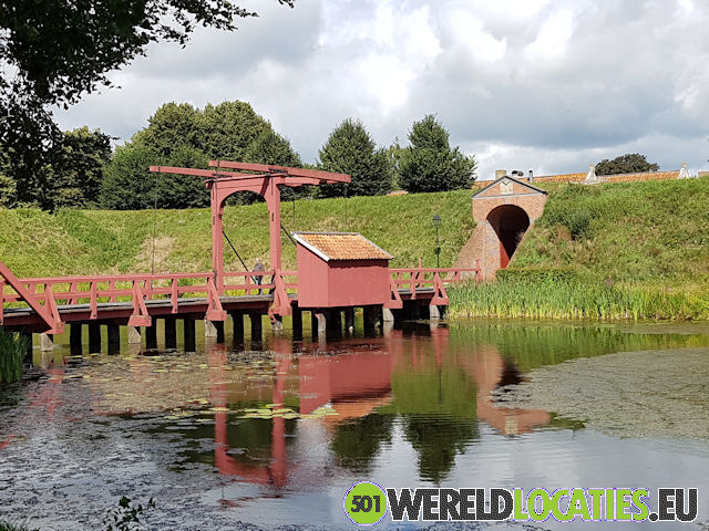
Netherlands - The Terra Mora museum explains why William of Orange, in his fight against the Spaniards, ordered the construction of Bourtange. The marshy area east of Groningen formed a natural defense for the city. Whoever controlled the paths—called the "Tanges"—through ...
The Ir Wouda pumping station in Lemmer

Netherlands - On a large model of Friesland, one of the men shows how the various pumping stations keep Friesland dry. Normally, the Wouda pumping station does not have to operate. Only in extreme weather conditions does the old steam pumping station still come into ...
The Keukenhof
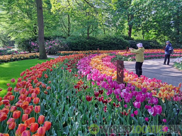
Netherlands - Keukenhof is one of the largest and most famous flower gardens in the world, located in Lisse, the Netherlands. The garden is open annually from March through May and attracts thousands of visitors from home and abroad each year. Keukenhof covers an area ...
The old mill of Zeddam
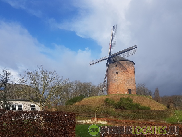
Netherlands - The old mill of Zeddam is one of the oldest mills in the Netherlands and a beautiful example of traditional Dutch windmills. This mill is located in the charming village of Zeddam, in the province of Gelderland, in the eastern Netherlands. The mill was ...
The windmills of Kinderdijk

Netherlands - The nineteen windmills of Kinderdijk symbolize the way the Netherlands manages its water. For a long time, they kept the land dry in an area plagued by subsidence and flooding: the Alblasserwaard, once a rough and marshy peatland, but eventually colonized ...